


You may have seen Ray Harryhausen credited with Technical Effects (meaning special effects) for his amazing stop-motion animation in movies like Mighty Joe Young, It Came From Beneath The Sea, and The Beast From 20,000 Fathoms. Well, this column isn't really about special effects, just technical game details and behind-the-scenes programming stuff that we thought you might find interesting. We'll be updating it regularly, or whenever Lars thinks of something.
03/07/04: WE BUILT THIS CITY ON ROCK AND ROLL
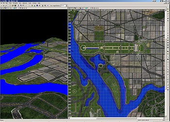
Well, not exactly, but I assure you there was some rock and roll involved. Here's how we make a map. First, I download the DEM (digital elevation model) files from any of the several US Geological Survey database sites. We use the highest resolution DEMs available - usually we need 4-8 DEM files per city to cover all the interesting areas. After merging the DEM files using MicroDEM , the merged DEM file is imported into Leveller where I crop and rotate the map. I may nudge a land mass somewhat to make it fit on the map, or remove features that aren't important. We also need to add underwater terrain for the transparent water effect, eliminate piers, re-draw lakes and rivers, etc. Then it's time to export an overview map with water to use as a template for painting terrain. I export a 24-bit elevation map for use in POVray 3.5 to raytrace the master terrain image, which is then divided into tiles.
Washington DC in Leveller
I CAN SEE MY HOUSE FROM HERE
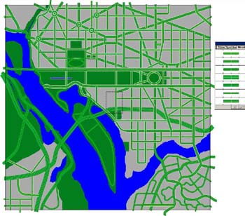
Using aerial and satellite photos for reference, I "color in" (texture) the terrain.
Washington DC in Leveller, textured
ROADS
Using Illustrator, I draw in the major streets, referring to our handy DC map and my fond childhood memories of visiting the Smithsonian and the Air & Space Museum. At this point I have to decide what roads to keep and what roads won't fit. We have to fudge a little, due to scale issues.
Drawing roads
ROAD DIRECTIONS
Referring again to my DC map, I use two special red and green "lane" brushes to make a map showing the traffic flow. This map is used to "tell" the game engine which directions the cars should drive. Why is it pink? I don't know. Lars did that.
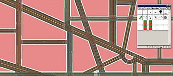
Drawing lane directions
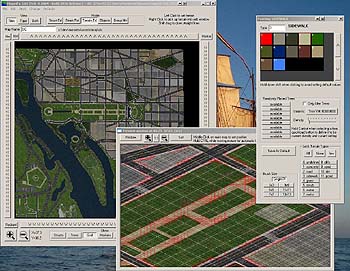
TERRAIN TYPES
Using MapEd, our custom tool, I mark the different terrain types (my invaluable third-grade-Fire-Safety-contest-trophy-winning ability to color within the lines comes in handy here). This lets the game engine know where and how the tiny people should walk. For example, people can run fast on sidewalks and roads, but not on rocky or sandy ground. Of course, they can't walk on the water (miracles excepted). The monster (depending on type) may walk more slowly through water and on rough terrain. I also label the different neighborhoods and landmarks (this information will show up on the in-game map) and I set the type and amount of trees that will appear on the grass tiles.
 |
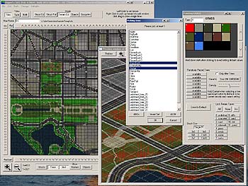 |
Setting terrain and trees in MapEd
BUILDINGS
I create and collapse all the city landmarks (yup, that's a gimongous step I'm skipping over here) , place them where they go on the map, and then fill in around them with suitable generic buildings. I also place all the streetlights, traffic lights, stop signs, fire hydrants, basketball nets, mailboxes, billboards and other tiny street-level stuff.
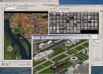
Washington DC in MapEd
FINISHING TOUCHES
From MapEd, I export a version of the map that shows where all the buildings are placed. Using this as a reference layer, I color in the details in Photoshop, adding baseball fields, parking lots, driveways, yards, etc. I bring this back into MapEd, export the binary map and - finally - it's ready to go into the game. Lather, rinse, repeat.
-- Sparky
PREVIOUS ARTICLES:
- 12/18/03: A.I.
- 08/28/03: PREFETCHER
- 04/22/03: BITMAP MEMORY DEBUGGER
- 04/22/03: MINI MAP
- 03/01/03: THEREMIN PROJECT X
- 02/08/03: YOUR MONSTER'S MANY MOODS
- 01/01/03: BUILDING COLLAPSE SEQUENCES
- 12/01/02: BOX LISTS
- 10/28/02: HAZARD MAP
- 10/18/02: TERRAIN TILES
- 10/06/02: BUILDING TRANSPARENCY
- 9/25/02: WIND MAPPING
 | © 2004 Octopus Motor They Came From Hollywood is a registered trademark of Octopus Motor |  |